Garmin esindus Eestis - tule liitu klubiga.
Maksa hiljem 3 osas - 0€ sissemakse, 0€ lisatasu
Toode on arhiivis, kuvatakse vaid informatiivsel eesmärgil.
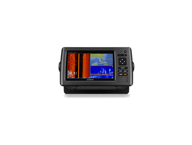
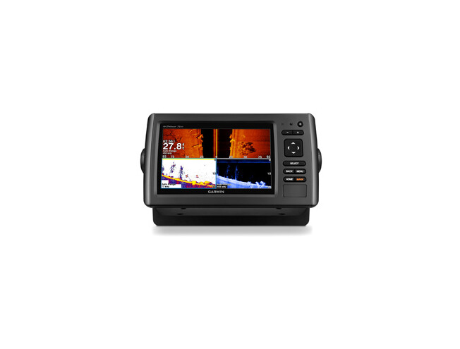
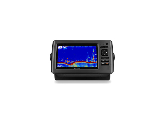
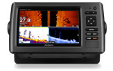
echoMAP 71sv includes a 7-inch high-contrast colour display with automatic backlight adjustment. Fast, responsive 5 Hz GPS/GLONASS refreshes your position and heading 5 times each second to make your movement on the screen more fluid. echoMAP 71sv has built-in support for 50/200 kHz, 77/200 kHz and Garmin DownVü™/SideVü™, the clearest scanning sonar on the water. It also supports Minn Kota® and MotorGuide® trolling motors with integrated transducers. The combo's cords plug directly into the mount, allowing you to quickly install and remove your device from power and the mount.
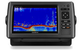
Garmin DownVü scanning sonar gives you a nearly photographic image of what passes below your boat. Garmin SideVü scanning sonar gives you a crisp, clear view of what lies up to 500-feet off to each side of your boat. You clearly see structure, submerged objects and fish. Traditional Garmin HD-ID sonar and both DownVü and SideVü scanning sonar are combined into one transducer. Also provides HD-ID support for Minn Kota and MotorGuide trolling motors with integrated transducers. The echoMAP 71sv also includes sonar-recording capability that coordinates the timing of the sonar return with your boat's position and saves digital information for playback on a computer using free HomePort™ planning software. Use the User Data Sharing Cable to share waypoints and routes between multiple devices.
Fast, responsive 5 Hz GPS/GLONASS refreshes your position and heading 5 times each second to make your movement on the screen more fluid. It makes dropping up to 5,000 accurate waypoints and finding your way back to your secret fishing hot spots quick and easy.
When you’re off the water, it’s easy to keep your echoMAP safe and secure. You don’t have to mess with plugging and unplugging wires from the unit because the cords plug directly into the mount. This allows you to quickly install and remove your echoMAP from power and the mount.
A single microSD™ card slot provides expandable memory for accessory map purchases such as BlueChart® g2 or BlueChart g2 Vision. BlueChart g2 Vision provide exclusive Garmin Auto Guidance that directs you right to your hot spots by instantly creating an on-screen path based on your boat’s specifications that you can follow to avoid shallow water and other charted obstructions.
Just enter the location where you want to go and patented Garmin Auto Guidance technology instantly searches through relevant charts to create a safe virtual pathway on the display that helps you avoid low bridges, shallow water and other charted obstructions en route.
Better still, with enhanced Version 2.0, you now have access to even more features and capabilities. You’re able to adjust the calculated Auto Guidance pathway by inserting “via” points at interim stops or landmarks along your desired route. You can easily review hazard points along your calculated path. And you can even engage your compatible Garmin autopilot to follow the Auto Guidance route, automatically. Other 2.0 enhancements give you the ability to calculate arrival times at any point on your route (great for timing arrivals to correspond with bridge openings and other time-critical events). Better still, you can now save your plotted Auto Guidance paths for future navigation by backing them up on an SD™ card with your BlueChart® g2 Vision® cartography².
If you have waypoints, tracks or frequently used routes stored on another manufacturer’s GPS product – or on a Garmin handheld device – now it’s easier than ever to transfer those items to your new Garmin chartplotter, via industry-standard GPX software formatting. GPX is an open standard format for GPS data exchange across platforms and applications. With this easy-to-use interface technology, Garmin has taken “no waypoint left behind” to a whole new level of trade-up convenience.
¹Applies to versions with transducers included only. No transducer versions support 50/200 kHz and Garmin DownVü/SideVü transducers, sold separately. See transducer selection guide for complete list of compatible transducers.
²BlueChart® g2 Vision® SD card is required for this technology.


Physical & Performance | |
| Physical dimensions | 9.8"x5.5"x2" (25cmx13.9cmx5.1cm) |
| Display size, WxH | 6.0"x3.6"; 7.0" diagonal (15.2 x 9.1 cm; 17.8cm diagonal) |
| Display resolution, WxH | 480 x 800 pixels |
| Display type | WVGA display |
| Weight | 1.7 lbs. (0.77kg) |
| Water rating | IPX7 |
| Antenna | Internal only |
| NMEA 0183 compatible | yes |
| Power consumption | 7.1W |
| Mounting options | Bail or flush |
| Garmin Marine Network™ ports | None |
Maps & Memory | |
| Preloaded maps | None |
| Accepts data cards | 1 microSD™ card |
| Waypoints | 5,000 |
| Routes | 100 |
| Track log | 50,000 points; 50 saved tracks |
Chartplotter Features | |
| Garmin Sonar compatible | Yes |
| Supports AIS (tracks target ships position) | yes |
| Supports DSC (displays position data from DSC-capable VHF radio) | yes |
| Tide tables | yes |
| BlueChart® Mobile (planning) compatible | No |
| Garmin Helm compatible | No |
Sonar Features & Specifications | |
| Dual-frequency (50/200 kHz) sonar capable | yes |
| Dual-beam (77/200 kHz) sonar capable | yes |
| Transmit power | 500 W (RMS) / 4,000 W (peak to peak) |
| DownVü™ | Yes (built-in) |
| SideVü™ | Yes (built-in) |
| Maximum depth | 2,300 ft @ 77 kHz, freshwater 1,100 ft @ 77 kHz, saltwater (depth capacity is dependent on water bottom type and other water conditions) |
| Bottom lock (shows return from the bottom up) | yes |
| Water temperature log and graph | yes |
| Sonar recording | yes |
| Sonar history rewind | yes |
Connections | |
| NMEA 0183 input ports | 1 |
| NMEA 0183 output ports | 1 |
| Video input ports | None |
| Video output ports | None |
| Wireless connectivity | No |


Kevad kampaania
Kas oled kevadeks valmis?
Meil on Sulle pakkuda menukad mudelid
väga hea hinnaga.
